Glacial incisions of the snowball Earth
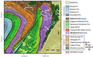
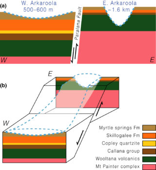
There are surprisingly few lines of geological evidence for glacial incisions associated with a snowball Earth scale event that are not controversial. A recent article published by members of the Earth Dynamics Research Group reports multiple lines of geological field evidence for deep but variable glacial erosion during the Sturtian glaciation (ca. 717‐659 million years ago, Ma).
Unlike current-day glaciers, which only occur in the mid-to-high latitudes, several Precambrian glaciations show an affinity for “snowball Earth” conditions (where the polar ice caps potentially extended into the tropics to meet at the equator). While the snowball Earth hypothesis has gained favor in recent years, there is little consensus on the erosion rates during the glaciation period. In this publication, the heterogeneity in snowball glacial incisions (reported here and elsewhere) were likely associated with the breakup of supercontinent Rodinia.
Contact person: Ross Mitchell, Earth Dynamics Research Group, Curtin University.
Relevant publication:
Ross N. Mitchell, Thomas M. Gernon, Adam Nordsvan, Grant M. Cox, Zheng‐Xiang Li, Paul F. Hoffman, Hit or miss: Glacial incisions of snowball Earth. Terra Nova, Volume 31, pages 381– 389 (2019).; doi.org/10.1111/ter.12400.